Waterfront Space Injects Life to Urban Development: Shanghai and Barcelona
Waterfront Space Injects Life to Urban Development: Shanghai and Barcelona
Scan with
wechat to share

Water has always played a vital role in the birth and progress of human civilization, whether it was in the Mesopotamia, the Nile Valley or the Yellow River basin. Water was not only helpful in solving the problems of irrigation, drinking, and sewage disposal of cities that existed in ancient times, but also offered a means of transportation, an important basis for the development of civilization in the Mediterranean region.
However, with urban development and changing needs of urban dwellers today, the relationship between humans and water has become increasingly complex. Trending changes in the waterfront cityscape can give us a glimpse into the ups and downs that cities are going through. Shanghai in China and Barcelona in Spain benefit from water resources from the river and the sea, respectively. Nevertheless, their urban development is characterized by a similar relationship with water.
Emerald of the Mediterranean
The peaceful Mediterranean gave birth to the earliest seamanship in human history. Barcelona is a city founded by the Phoenicians when they explored the Mediterranean from the west to the east in before-Christ days.
Barcelona developed into city scale when the Roman Empire dominated the Mediterranean. At the time, city walls kept Barcelona from coastal areas to defend it against enemy attacks from the sea. People could only enter the city through the city gates. Although the city was expanded, the defensive function of the city walls remained unchanged.
During the ruling of the King of Aragon in the 14th century, Barcelona boasted the most powerful naval marina at that time. Artillery became the main weapon for maritime warfare. Barcelona built two military fortresses on its two flanks. Like the pincers of crabs, the military fortresses well protected the city.
Barcelona ushered in rapid development when the Industrial Revolution began. Unable to find a shelter in downtown areas, numerous migrant workers had to gather outside the city walls in the peninsula of the Mediterranean. The peninsula bore the brunt of war, but thanks to its proximity to the sea, the area, known as Barceloneta, quickly emerged as a popular gathering place for workers and fishermen.
Barcelona demolished its city walls in 1854, and the world-famous Cerda Plan was brought up. The city began to expand inland, and the coastal area of Barceloneta gained prominence thanks to convenient transportation on the Mediterranean. It was also during this period that the city’s first railway opened to traffic in the coastal area. All of this made it a prime choice for setting up factories.
In 1932, Le Corbusier, an internationally influential Swiss architect and city planner, was invited by the Group of Catalan Architects and Technicians for the Progress of Contemporary Architecture (GATCPAC) to design for the development of Barcelona’s coastal area. Corbusier presented Plan Macia, the first contemporary plan for industry-based development of a coastal area, as well as the first urban plan to address the need of the middle class for seaside vacations. The plan tried to turn the seaside area into a public space and integrate it into the structure of the city. Unfortunately, under the dictatorship of Francisco Franco, the plan to renovate Barcelona's coastal area was shelved. In the ensuing decades, the area plunged into a slum.
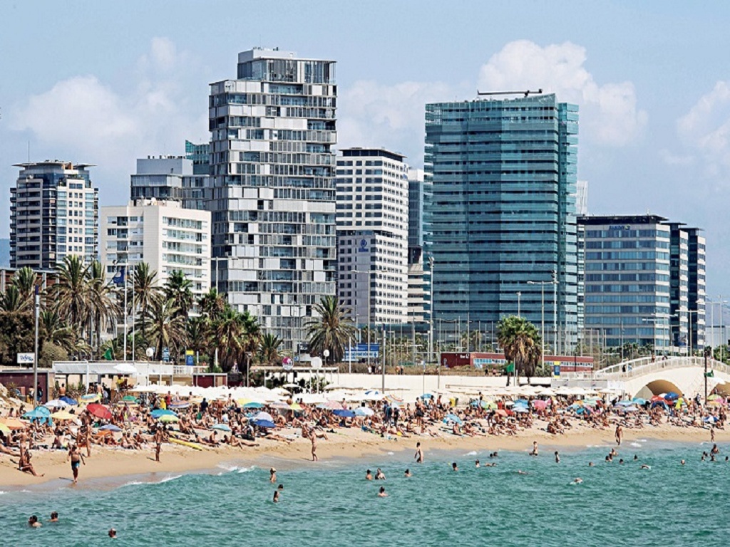
Spain’s economic take-off and the recovery of international tourism in the 1970s revitalized Barcelona's coastal area. Convenient transportation, pleasant climate and quality sandy beach made it a popular tourist destination for people in northern Europe. At the time, the slum was demolished, and the coastal area began to gradually transition from an industrial area to a tourist destination.
Barcelona’s win in the bid for the Olympic Games in 1986 ushered in a round of comprehensive upgrading of the coastal area. The most important measures were the building of the seaside sunken ring road and the renovation of the former industrial zone based on the Olympic Village.
The former solved the problem of accessibility for residents of the entire area. The sunken ring road maintained the elegant coastal skyline. In the renovation, a number of high-quality residential compounds were built. The buildings where journalists and athletes stayed during the 1992 Barcelona Olympic Games were designed as commercial housing in the first place.
At the seaside end of the Olympic Village are two twin towers, which are as high as high-rises envisioned in the Plan Macia. In post-Olympic times, the twin towers emerged as a center of restaurants, hotels and casinos. With the influence of the Olympic Games and urban renewal efforts, Barcelona became one of the most popular high-end tourist cities in the world. In 2000, the city welcomed seven million tourist arrivals.
The increase in tourists has driven the continuous adjustment of regional business. Rounds of feasibility study on relocating businesses in the large port in the southwest were carried out, but the city doesn’t decide on whether to keep the port or renovate it into an international business district. The coastal area in the northeast continued the momentum of the Olympic Village, but it didn’t develop into a core tourism area as planned. Businesses in the area have been navigating from the tourism sector into cultural, convention and exhibition sectors. Local residents are replacing tourists in using the waterfront space.
Pearl of the Huangpu River
Geographically, Shanghai is located in the Taihu Lake Basin area. The Wusong River (now Suzhou River), one of the three rivers that flowed through the ancient Taihu Lake area, was the last tributary of the Yangtze River before it joins the sea. After a large-scale water conservancy project that was conducted during the early 15th century, the Wusong River changed from being a tributary of the Yangtze River to being a tributary of the Huangpu River. Following that, the Huangpu River became the main shipping lane in Shanghai.
Shanghai was opened to foreign business as a treaty port in 1843. The British set up concession on the Bund. From the end of the 19th century to the 1930s, with the expansion of the concession and the influx of foreign capital, the Bund became a gathering place for banks, trading companies, hotels, and consulates. Buildings in the Bund are of different architectural styles, and the area was therefore known as an “international architecture exposition.”
With the agglomeration of buildings and the prosperity of commerce, public space in the Bund was gradually expanded and improved. Urban planners built wide roads and sidewalks along the Bund, landscaped the area and placed street lights. In the 1980s, local government carried out large-scale renovation of the Bund. In the late 1990s, the construction of a viewing platform in the Bund became a key project in Shanghai. With a total length of about 1.5 kilometers, the viewing platform extends from the mouth of Suzhou River to East Yan'an Road. It provides not only an ideal viewing area for tourists, but also a venue for local residents to take walks and relax. The Bund Tunnel, an underground expressway, opened to traffic in 2000, offsetting some negative impacts of motor vehicles on pedestrian space, and the city's most iconic waterfront public space took shape.
Located opposite the Bund is Lujiazui financial district. Before the founding of the People's Republic of China in 1949, it was mainly an farming area, with residential areas scattered here and there. The development of this region was relatively slow, standing in stark contrast to the prosperity of the Bund.
In 1990, China officially announced its plan for developing the eastern area of the Huangpu River. Iconic buildings, such as the Oriental Pearl Tower and the Jinmao Tower, rose sheer from the ground during this period, gradually forming the city skyline along the waterfront that everyone is familiar with today. The waterfront area of Lujiazui attracted a large number of high-end commercial complexes, such as the Shanghai Tower, and the World Financial Center among other super skyscrapers.
Today, the Pudong New Area values efficient use of waterfront space more than the building of high-rises. World top-notch cultural and art facilities, such as the Museum of Art Pudong and Lujiazui Concert Hall, are reshaping the waterfront skyline.
The Shanghai World Expo 2010 brought significant changes to the waterfront on both sides of the Huangpu River. Originally, the river banks were home to a large number of old factories and docks. In preparation for the World Expo, the local government carried out a large-scale renovation project, covering a total area of about 5.28 square kilometers on both sides of the river. The purpose was to transform the original industrial area with old facilities into a comprehensive urban space integrating cultural, commercial, residential, recreational, and other functions, and improve the ecological environment and landscape of the waterfront area. The development of the waterfront area for the World Expo has been vital to Shanghai's urban development. Shanghai took the opportunity of hosting the World Expo and successfully transformed the old industrial area into a modern and comprehensive urban space with excellent ecological environment.
The Shanghai Riverside Promenade, spanning 45 kilometers along both banks of the Huangpu River, opened on the last day of 2017. New opportunities emerged in renovating and preserving industrial heritage in the riverside area.
Whether it's Barcelona or Shanghai, the Mediterranean or the Huangpu River, the changes of waterfront areas mirror the changes of a city. The current debate in Barcelona over whether tourism or local residents should come first, or that in Shanghai of whether its commercial position or cultural industries should take precedence, are incisively connected with the waterfront areas. In densely populated urban areas, waterfront space offers an ideal buffer zone as the wide view field in waterfront areas extends people’s view, and creates a comfortable viewing experience. While functioning as a boundary line, waterfront space gives birth to a unique charm created by the collision of two different geographical features. Being a boundary line, waterfront area indeed affects the development or expansion of a city as evidenced by the city walls in Barcelona and the backwardness of the eastern area of the Huangpu River. However, the unique charm is the ultimate force that makes waterfront space the landmark of a city. Likewise, what the Qinhuai River is to Nanjing is what the West Lake to Hangzhou. 
TIAN WEIJIA is an associate professor at College of Architecture and Urban Planning, Tongji University.